Summer of Fire
A yearly camping trip in Banff National Park descends into distress as this couple manoeuvres home amid the B.C. and Alberta fires of ’21.
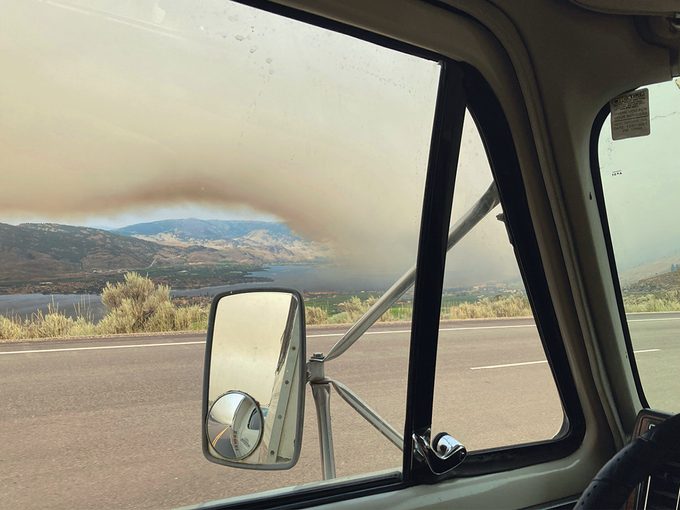
We’ve all seen on television the devastation of summer wildfires across Canada. Back in 2020, the town of Lytton, B.C. burned to the ground; huge tracts of forest from Alberta to Ontario lost due to flames; smoke advisories across multiple provinces; firefighters from as far away as Mexico offering their aid. The list goes on.
Vancouver Island—where my wife, Cathy, and I live—escaped the worst of the 2021 wildfire season. Although we did suffer 40°C temperatures from June’s heat dome, there were no major fires on the island. Nor were there air-quality advisories due to wildfires in U.S. states to our immediate south—namely Washington, Oregon and California—as there’d been in previous summers.
We’re both in our late 60s and semi-retired. We like to go camping every summer. We stay at provincial and national parks, and absolutely love the natural surroundings these parks offer. But tourist travel simply did not happen in the summer of 2020. Even travel between municipalities was discouraged. To put it bluntly, not much of anything happened that summer—actually, make that all of 2020. I have to admit that after a year of these limitations, we were both suffering from major cabin fever.
On the Road Again
Interprovincial travel was just opening back up in the beginning of July 2021. Lockdown restrictions due to the COVID-19 pandemic were being lifted, and campgrounds were once again accepting campers. Things seemed to be getting back to some level of normalcy.
We were well aware of the fires burning in British Columbia’s Fraser Canyon. The Trans-Canada Highway was closed to all traffic due to the fire in Lytton, but highways 5 and 3—the Coquihalla and Crowsnest, respectively—were both still open, with no travel advisories or wildfire warnings along either road. We were free to choose our route for a visit to one of our favourite destinations, Banff National Park. We decided to make the trip in a clockwise direction, driving the Coquihalla on the way out and the Crowsnest back home.
We set forth on our road-and-camping trip on July 6, a Tuesday. The drive out was uneventful—until we reached Kamloops. Just east of the B.C. city’s limits, we were hit by a huge windstorm. The brown and black dust picked up from nearby hillsides was so thick that visibility was near zero. Fire-danger levels in the area had been rated as “extreme” for weeks and everything looked bone-dry. I thought that if there was a spark—even one single spark—half of the eastern end of Kamloops would burn to the ground in minutes.
Oddly enough, from Kamloops to Banff there was little, if any, indication of wildfire season. In fact, the skies were crystal clear throughout our leisurely seven-night stay in the national park. South of Banff and along Alberta’s Highway 22 (known as The Cowboy Trail), however, was a different story.
“Save Our Land”
Heading home along The Cowboy Trail, the air was smoky and hazy from new daily fires burning in southern British Columbia. You could taste the air.
Castlegar, B.C., was even worse. The smoke was so bad that the RCMP had to install LED advisory signs along Highway 3, with speed limits reduced to 70 kilometres an hour due to poor visibility.
Driving while my wife was constantly checking for road closures and wildfire conditions with DriveBC—the province’s official source for traveller information—always checking the horizon for smoke conditions and not wanting to stop anywhere for fear of being stranded was very unsettling.
But none of this prepared us for the sinking feeling that came over us as we saw the scene unfold just outside of Osoyoos, B.C., on July 20 of 2021.

The sky was an eerie shade of brown that I’d never seen before, but which I understood to be a sign of not just a forest fire, but of structures burning as well. So we knew things were bad.
The town of Osoyoos itself was dead quiet, with the few people outside on the downtown streets walking in a trancelike state. (Later, pausing at a lookout along Highway 3 on the west end of Osoyoos—pictured above—we would note that the general mood among the locals and other travellers was one of shock.)
No boats or pleasure craft of any sort were out on Osoyoos Lake, despite it being the height of tourist season. Instead, the lake was reserved for the water bombers that were repeatedly circling and refilling their tanks to fight the many ongoing fires. There were constant new flare-ups on the surrounding hillsides. Still, the water bombers’ efforts seemed futile at best. The atmosphere was almost apocalyptic.
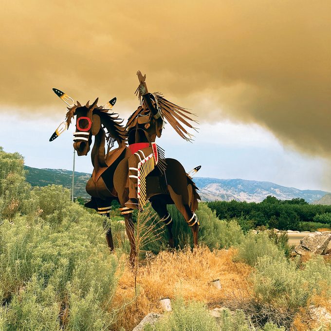
A sight from earlier on seemed to foreshadow this scene, when we’d happened upon a striking steel sculpture of a First Nations horse rider near the eastern edge of Osoyoos, by the Petro-Canada service station at 45th Street and Highway 3. The rider is sitting atop his horse with his arm raised to the sky. The stark contrast between the blue horizon and all that thick brown smoke lasted only a few moments before the wind blended it all together.
I was so taken by that scene. It brought tears to my eyes then, and it still speaks more than a thousand words today. To me, it appeared as though the rider was crying out to the Creator and Great Spirit: “Please help save our land!”
The horse and rider sculpture is one of many created by Indigenous artist Virgil “Smoker” Marchand. A similar statue welcomes visitors to the nearby Nk’Mip Desert Cultural Centre, in Osoyoos.
Next, read the terrifying story of the deadliest forest fire in Canada’s history.
